Thursday 27 May 2010

LAX Airspace VFR transition

This is a flight I had to cancel four times due to scattered clouds at 2500ft above LAX, which does not permit doing the VFR "mini-route" transtion.
The ceiling needs to be 3000ft or more, and 3 miles visibility at least.
Monday was the day, I called the weather briefer, we got the meteo en-route, at destinations, Notams and TFR checked.
Straight-out departure runway 28L at Montgomery, heading towards the coast before turning right and climbing to 6500ft. We had "Flight Following" all the way to Los Angeles and that was really helpful, those guys are doing a great job.

First entry point over Los Angeles was the Queen Mary. Then, passed onto Hawthorn Tower, and joining the 128° SMO VOR Radial, I got the pre-clearance message. Reporting over Hawthorn & 405 Freeway, I was transfered onto LAX Tower. "Los Angeles Tower, Cessna 3386E, inbound mini-route". "Cessna 3386E, Los Angeles Tower, squawk 0215 and ident". "Cessna 3386E, you're cleared through the Los Angeles Bravo airspace, , maintain 2500ft, VFR, altimeter 3007".
The track to follow was basically the 128 radial all the way to Santa Monica airport 5 miles North of LAX. We enjoyed an incredible view over the terminals, with airliners landing and departing from everywhere! This is hard to imagine until you've been there.


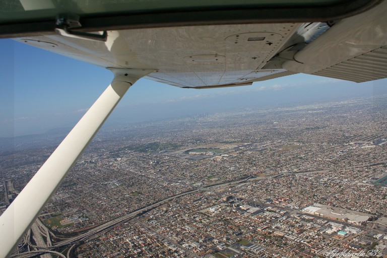
Over Santa Monica airport, we turned eastbound, descending at 1500ft altitude. We overflew UCLA, Beverly Hills, with Hollywood not far away, Dodger Stadium and downtown LA, another 10 miles to join the pattern at El Monte airport and landing runway 19. We had lunch there.

At that point, we realised that all the photos taken over LAX were extremely bright and almost unviewable. In fact, somehow we went fromthe Aperture priority setting to the Manual mode, and the pre-selected speed was way too low for such a bright day.
The plan was to land at Ontario Intl to then depart back to San Diego, inland. But there was no way I was going to leave without the photos of LAX.

Two hours later and the flight replanned, I landed the Cessna on Ontario International runway 26L, stopped the plane on the taxiway and contacted Ontario Clearance Delivery. "Ontario Clearance, Cessna 3386E, clear of 26L at T, request flight following to Santa Monica via Long Beach and the LAX mini-route transition, 4500ft". "Cessna 3386E, Ontario Clearance, after take-off turn right heading 285, altitude 3000ft or below, first departing frequency will be 125.3, transponder 5111". "Right 285, 3000ft or below, 125.3 and squawk 5111, Cessna 3386E". "Cessna 86E, readback correct, contact ground point niner". "Ground 121.9 Cessna 86E, thank you".


Take-off 26L, in the climb-out, we intercepted the 187° Radial of the POM VOR [110.4], the second VOR was set on the PDZ beacon [112.2], radial 242, which, when intercepted, would be our turning point south of the Bravo airspace. Socal Approach transfered us to Hawthorn TWR, once again, and we soon got cleared into the Los Angeles Bravo airspace. Transiting vertical LAX at 2500ft, we took about more than a hundred pictures, at 70kt with flaps 10° (to get enough time to enjoy the view). Santa Monica in sight, we joined the pattern, made a left base 21, a touch-and-go over Tom Cruise's private jet. 270° over the coast, back overhead Santa Monica airport, inbound LAX mini-route Southbound ... a third time !! Oh yeah, we just love that transition !!

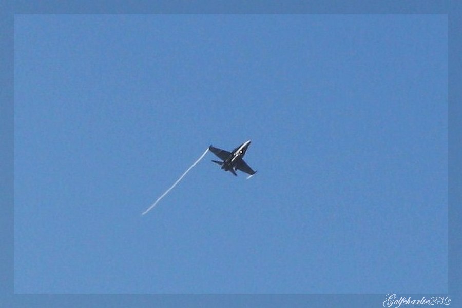
Heading back to San Diego, a Southwest Boeing 737 departing John Wayne flew right below us (we were cruising at 5500ft) and I took one of the best picture I've ever taken !
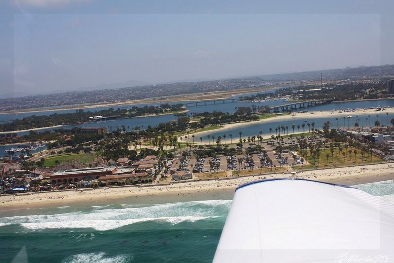
Arriving in San Diego, a thin cloud layer was forming along the shoreline with the sun slowly coming down above the horizon. What else could we ask for after such a flight?

Sunday 23 May 2010

Flight to the Californian Desert

After quite a bit of time spent flying along the shoreline or in the area, we headed up to something totally new to me: The desert.
The flight took us across the mountain ridges, less than a hundred miles of San Diego. We flew Northeastbound towards El Capitan Reservoir, and right up the highest summit in the area (Cuyamaca Park at 6500ft altitude). We were cruising at 7500ft altitude and another 2000ft wouldn't have been too much, the wind was blowing straight towards the edge and the downward wind movements just behind it were quite strong. At some point we were full power at the best climbing speed trying to maintain the plane levelled. And at some other point, we were almost powered on idle, trying not to climb ... This is how strong the upward/downward winds get over there ...

Over Cuyamaca lake, we started our descent to the destination airfield : Agua Caliente (L54), which is more a runway than an airfield. There is a strip to land the plane, and that's pretty much it, there's not much else. A road, some snakes, a bit of wind and a crinkling noise from the old road signs to add some oddness to the scene ...
I had a feeling kind of close to what we get watching an horror movie ...
It would have got creepy if the engine hadn't started.


We then flew to Borrego Valley airport, further North. Another desert behind a West-East mountain ridge, a golfcourse, a very small town named Borrego Springs, and an airport in the middle of nowhere ... 5000ft of runway with enough facilities to handle a jet, we landed our Piper Cherokee and parked in front of the local restaurant, where we were the only customers.
And still that clinckling noise from the road signs in the wind that reminds me of horror movies ...
The meal was delicious for such a decent price tag. Back on the apron at a temperature around 100°F (38°C), engine started, a message on "Borrego Valley traffic" to say our intentions to depart South-bound, and here we are up in the air again.


We flew back to San Diego at 8500ft, tried the autopilot, and arrived in a building smog that was moving more deeply inland. The visibility wasn't good at all and this is where you have to rely on your charts and ground landmarks to be sure you're going the right way. At that moment, Montgomery had only runway 23 in service (the one crossing the doublets 28L and 28R) which is used when the wind blows that way. I was cleared to land number 2, entering the pattern via a left base 23. It worked out fairly well and that ended up a pretty busy week quite nicely.

Thursday 20 May 2010

Flying to Los Angeles

Today, we planned a flight to El Monte through the LAX mini-route and a landing at John Wayne airport on the way back.

We had to postpone the flight twice due to bad weather along the coast. Today was forecasted to be overcast on the shoreline until 13:00. Unfortunately, by the time we were planning on starting the descent, the mini-route was closed and we had to divert to John Wayne (Orange County, CA). If weather permits it, we are flying to El Monte and Ontario Int through the mini-route on friday.


It was still quite an enjoyable flight and having to divert is a good teaching experience. You have to replan the flight, tell the controlers your intentions, figure out how you get to your new destination, get the ATIS and all the information you need within a very short amount of time.
At the same time, the controler asked us to turn through a 090 heading in order to avoid an incoming traffic, and flying Eastbound got us closer to John Wayne Airport. Flaps out, expediting the descent as we had left Flight Level 65 (6500ft) only a minute ago, we were transfered onto John Wayne TWR, we passed our message and we were cleared through the mid-field overhead and left traffic pattern for a Runway 19L landing. As we were on final, a Southwest Boeing 737 was landing on the parallel runway.

On the ground, cleared of 19L, we contacted ground to taxi to the FBO. So, what is a FBO? For a european pilot, that seems totally new. And indeed, this is something we simply don't have in Europe.
On middle size airports like John Wayne, they have 2 FBOs. Some airports have more, some have only one, and some don't have any.
A FBO is basically a handling facility which looks like a could be defined as some kind of a business terminal. The main difference being that any pilot, either leisure pilot or commercial pilot, gets the same services. They are the ones refueling the aircraft, arranging transportation to a hotel, marshalling the planes on the apron, carrying our baggages, or lending a car for a few hours.
In the FBO in itself, they've got everything a pilot would need. Crew rooms, meeting rooms, flight planning rooms, and even a place to sleep when on duty and waiting for the next flight.


We got the keys of a Ford Mustang, this is one of the services that come with it and you do not have to pay for it. That was perfect as we needed to grab something to eat.


Airports such as John Wayne have a Clearance Delivery frequency we contact prior requesting taxi on the Ground Frequency.
This is the frequency that is going to coordinate our flight back to San Diego, and passing our information onto each of the next frequencies, and .. they give us our first clearance. "Cessna 2726E, after departing end-of-runway, turn left Heading 150, climb at or below 2400, departure frequency will be 124.1, Squawk 0240".

Heading to the shoreline via Dana Point (South-West of John Wayne), we chose to come back inland to transit over Miramar MCAS. At that exact moment, a F18 was touching down on the Westerly runway at Miramar. We then proceeded towards the overhead of Montgomery Field a few miles further South and entered the pattern for a 28L landing with 40° flaps, and for once that was a very smooth landing.

Saturday 15 May 2010

Getting to know the San Diego area

I've been flying everyday this week and that feels just great. I'm now based at Montgomery Field just a few miles North-East of San Diego International.

We've mostly been practicing the R/T which can get fairly busy in the area. Montgomery alone is home of 250,000 aircraft movements a year, operating on three paved runways, between two Class Bravo on a corridor that goes from the Coast to El Cajon (San Diego East).
North of Montgomery is MCAS (Marine Corps Air Station) Miramar, and not far on the South-West side San Diego Int and further South San Diego NAS (Naval Air Station) North Island. There is a VFR corridor that goes overhead Lindbergh (San Diego Int) to further south on the bay, but as a a way of getting used to Flight Following, we've been doing that with Socal Approach. They basically give us heading, altitude and squawk code for the transit until we get to our destination.

We got the chance to overfly the three active US aircraft-carriers, the bay, and do a VFR transition along the coast "at or below 500ft".


Saturday 8 May 2010

Arrived in America

After something like 22 hours of travel, I finally arrived in San Diego, CA.


I took the BA flight to London from Toulouse, a BA 777 to Chicago and connecting flight with American Airlines to San Diego Int.

I'm going to spend the next two and a half months over here doing my hours building before starting my CPL back in England in August.
I went to San Diego FSDO (FAA) on thursday to get my US certificate, which allows me to fly in the States under the same privileges I have as a Private Pilot in Europe. I currently have the temporary certificate and will get the US licence within the next three months.


I went flying the same day on the Cessna 172 N3386E. I must say, it was quite an enjoyable flight, and the Californian landscapes are definitely worth the sight!
We took off on Runway 28L, went into Bravo airspace over San Diego Int (Lindbergh) airport, flew over downtown San Diego heading towards the Bay, landed on Brown Airport 1 mile North of the border with Mexico, and did some circuits there.


Cessna 86Echo, request North-East bound departure", and as we leave Brown airspace, we contact 122.75, the Air-to-Air frequency.
"San Diego South-East, Cessna 86 Echo over Otay Lake at 2500, heading North-East bound towards San Miquel, San Diego South-East".


We went over Mont Helix in the El Cajon area (home of the busy Gillespie airfield), picked up the ATIS and contacted Montgomery TWR. "Cessna 3386E, 1 mile East of Lake Murray at 2600, with Hotel, inbound full stop landing". Cleared to land on 28L, and taxi to Gibbs apron.
We could hear and see the USAF F18 on downwind at Miramar AFB (where the movie Top Gun was filmed), it is indeed a great location.


Overall, I find the RT (RadioTelephony) to be easier than that in Europe, it is clearer and the calls are generally shorter. In the next few flights with the Flight Instructor, we're going to fly under Flight Following which is something we do not have in Europe.
Will follow some very interesting flights that will take me to the likes of Catalina Island, LA, Grand Canyon, Las Vegas, and many more other places as part of the time building.